High times with Halifax Transit

Over the last few decades, Canadians have made incredible progress reducing drunk driving and the associated carnage. This summer, cannabis will be legalized, and people are warning that this will lead to people driving while high – something that is equally as dangerous as drunk driving. We firmly believe that the best way to limit the negative impacts of impaired driving is to provide high-quality transit service so that driving is left to professional drivers and everyone else is free to enjoy a cider or a joint. So, how accessible are the four NSLCs that will sell cannabis in Halifax? Let’s find out.
Halifax’s four cannabis dispensaries will be located at the Sackville Superstore, Joseph Howe Drive Superstore, Portland Hills Superstore, and the former NSLC on Clyde Street. It seems odd to put three of the four at Superstores, especially when Sobeys is locally owned (and their logo is green, come on!), but we digress.
We analyzed how many people live within 15, 30, 45, 60, 75, and 90 minutes of each of the four locations. To capture changes in the schedule we ran the analysis to arrive at noon or 7pm on a weekday, and noon on a Saturday. If the only option for someone is to take a bus that arrives at 11:30am, this method of analysis adds 30 minutes to their trip, because it assumes you didn’t want to arrive at 11:30 and sit around waiting for an appointment. In practice, for going shopping, as long as the trip ends during the opening hours of the business people don’t care about the precise arrival time.

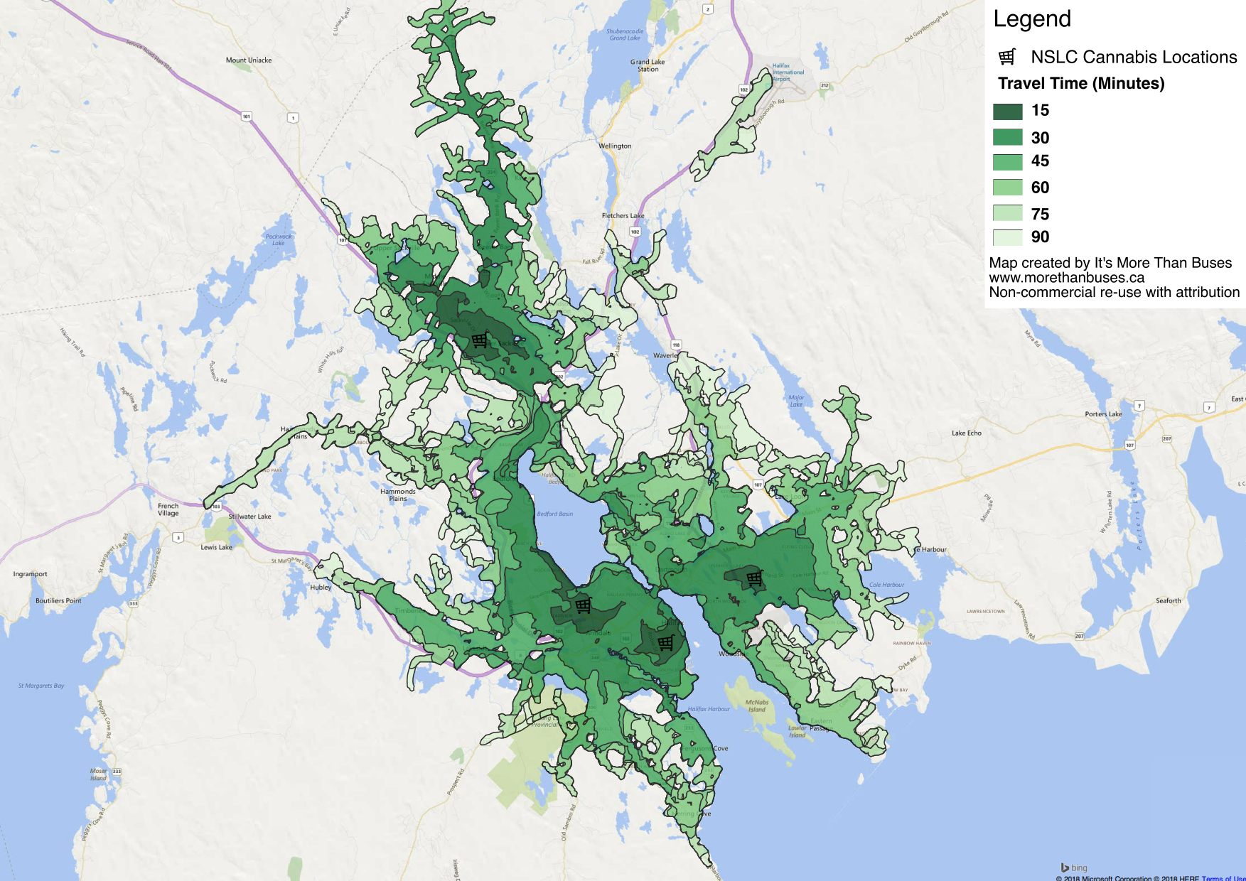
Travel time to the four NSLC cannabis outlets in HRM by Halifax Transit, weekdays at noon.
The figure below shows travel time to all four stores on a weekday at noon. The darker the green, the faster the trip. Most residents inside the transit service boundary can reach a store within 45 minutes. As the figure below shows, access is nearly identical in the core, but significant areas like Beaver Bank Road lose access on the weekend.

Cannabis outlet access, Saturdays at noon
The best access is in the early evening, shown in the figure below. This is when Halifax Transit is running its most complete service offering. This should be viewed with caution as peak services often run one-way only, and many stop running close to 7pm, meaning you may need to walk home. Taken together, these maps make a strong case that Halifax Transit is not providing great service outside of peak hours. Having fast, frequent, and reliable service all day, every day, would allow people to get to the store when it works for them.
Weekday evening (7pm) cannabis store access
A transfer-based networkwould also eliminate some oddities that we discovered when digging through the data. For example, residents of Hammonds Plains can only get to a store on weekday evenings. A trip from Hammonds Plains takes 75 minutes each way! The only store they can reach is on Joseph Howe Drive, rather than the much closer Sackville store, which would take 90 minutes. This is due to the design of route 33 Tantallon Express. A route running straight down the Hammonds Plains Road to Mill Cove. That route would provide a great connection to the 80, improving access to both Sackville and downtown Halifax.
Not surprisingly, the Clyde Street store has the best access. Located in the middle of the Halifax Peninsula 71,800 people can reach it in 30 minutes or less. It is a short walk from the heavily-travelled Spring Garden Road corridor, so it is also a short trip for residents of the tulip streets in Dartmouth.
With such limited access, we expect many Haligonians to keep their current delivery driver on speed dial.
To analyze transit access to the four NSLCs with cannabis we used OpenTripPlanner, a free software tool that does the heavy lifting required to analyze transit schedules; QGIS, a free geographical information systems (GIS) application; and 2016 census data on population. If you enjoyed this analysis, please make a donation to support our work.